Close Menu
Easy USSD Codes
  • Home
  • Banks
  • Telecoms
    • MTN
    • Airtel
  • Pay Tv
    • GOtv
    • DStv
  • Solar/Inverter
  • Phones & Gadgets
Facebook X (Twitter) Instagram
Easy USSD Codes
  • About Us
  • Privacy Policy
  • Terms and Conditions
  • Contact Us
Facebook X (Twitter) Instagram Pinterest
  • Home
  • Banks
  • Telecoms
    • MTN
    • Airtel
  • Pay Tv
    • GOtv
    • DStv
  • Solar/Inverter
  • Phones & Gadgets
Subscribe
Easy USSD Codes

Nigerian 6 Geopolitical Zones and Their States

By JoyceJuly 18, 2025Updated:July 18, 2025 Education
Nigerian 6 Geopolitical Zones and Their States

Nigeria has been divided into 6 Geopolitical Zones, but can you tell which state falls into each geopolitical Zones in Nigeria? The answer to this question is No, but we will learn that today in this guide. Your children might be asked to list the six geopolitical Zones in Nigeria, which might be hard for you to tell them off the head.

How and when did Nigeria divide into six geopolitical Zones


Nigerian 6 Geopolitical Zones and Their States

In the 1980s, a powerful politician from the “former” Southern area of Nigeria proposed dividing Nigeria into six distinct political regions.

He was concerned that the Hausa-Fulani, using the “one” North political gimmick to oppress other Northern ethnic groups and the rest of the country, would continue to dominate politics.
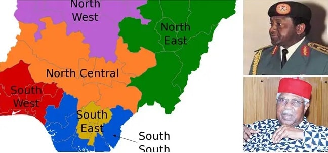
Thee military administration of Sani Abacha in 1995, however, is credited with the definitive establishment of geopolitical zones in Nigeria.

In Nigeria, there are six distinct political regions. The number of states that fall within each of Nigeria’s geopolitical zones is as follows:

1. South West (6 states)


  • Lagos
  • Osun
  • Oyo
  • Ekiti
  • Ogun
  • Ondo

2. South East (5 States)


  • Ebonyi
  • Abia
  • Anambra
  • Imo
  • Enugu

3. South-South (also known as Niger Delta region, 6 States)


  • Delta
  • Edo
  • Akwa Ibom
  • Bayelsa
  • Cross River
  • Rivers

4. North East (6 States)


  • Borno
  • Gombe
  • Adamawa
  • Yobe
  • Bauchi
  • Taraba

5. North West (7 States)

  • Jigawa
  • Kaduna
  • Kano
  • Katsina
  • Kebbi
  • Sokoto
  • Zamfara

6. North Central (also known as Middle Belt, 7 States)


  • Benue
  • Kogi
  • Kwara
  • Nasarawa
  • Niger
  • Plateau
  • Federal Capital Territory

Conclusion: Keep in mind that the North-East region has the most total land area. Terrorist organizations like Boko Haram and ISWAP launch their bloodiest attacks from this region.

ALSO READ  10 Ways to Study at Night for Long Hours Without Sleeping
Share. Facebook Twitter Pinterest LinkedIn Tumblr Email
Previous ArticleTecno Spark 10 Pro Price in Nigeria
Next Article Best 10 Sites to Mine Bitcoin for Free

Related Posts

10 Ways to Study at Night for Long Hours Without Sleeping

July 18, 2025

List of Professional Courses Offered in Nigerian Universities

July 18, 2025

The History of Social Media in Nigeria

July 18, 2025
Add A Comment

Comments are closed.

Top Posts

Who Owns MTN? History and Ownership of Africa’s Telecom Giant

July 26, 2025

Which Bank is the best In Nigeria in 2025?

August 25, 2025

Download Ecobank Mobile banking app

August 3, 2025

What is CVV in ATM Card? Full Guide to Understand ATM Cards

October 8, 2024

How to Block First Bank ATM Card: Step-by-Step Guide for 2024

October 8, 2024
Categories
Facebook X (Twitter) Instagram Pinterest
  • About Us
  • Privacy Policy
  • Terms and Conditions
  • Contact Us
© www.easyussdcode.com - All Rights Reserved.

Type above and press Enter to search. Press Esc to cancel.